You are using an out of date browser. It may not display this or other websites correctly.
You should upgrade or use an alternative browser.
You should upgrade or use an alternative browser.
NEPAL [ A Family Trekking Travelogue ] - by limwhow & SereneXMM
- Thread starter limwhow
- Start date
limwhow
Senior Member
Aaah, now I see!that bicycle on the right..
'norco' is well known bicycle brand
Norco Bicycles
while 'full sussy' or 'full suss' is what full suspension bicycles are affectionately known as in the cycling/mountain biking world.")
Thank you thank you. I am not familiar with mountain bikes. LOL..
Enjoying this thus far. As usual, high std travelogue and most importantly, highly entertaining !!!
:thumbsup::thumbsup::thumbsup::angel:
Thank you very much, chempaka!
I love the colours of your kyoto series!

limwhow
Senior Member
Day 3.. finally, we are starting to trek..
Overwhelmed with excitement, we all woke up at 6am to get ready for the one and a half hour ride to Nayapul.
Nayapul is a small little village where the actual trekking will start.
Located at an altitude of 1000m, Nayapul is the gateway village to Annapurna Base Camp.

Dawn is just breaking.
The son came out to enjoy a breath of fresh, cool air..
This young man is pretty tough. Apparently he has less of a fear of the cold than me.
Well, let's see how he does over the next few days.

I stood at the balcony and looked towards the rooms on my right.
The star above in the sky flickers, like signifying the starting of a new day.
Yupe. This will be a view which I will not be seeing for the next 5 days.

Looking ahead, Annapurna South peak and Hiunchuli peak smiled down, beckoning us to climb closer to them over the next few days.
It's interesting that now, in retrospect, I realise that over 6 days, I will see these mountains from a different foreground with a slightly different angle.

Overwhelmed with excitement, we all woke up at 6am to get ready for the one and a half hour ride to Nayapul.
Nayapul is a small little village where the actual trekking will start.
Located at an altitude of 1000m, Nayapul is the gateway village to Annapurna Base Camp.
Dawn is just breaking.
The son came out to enjoy a breath of fresh, cool air..
This young man is pretty tough. Apparently he has less of a fear of the cold than me.
Well, let's see how he does over the next few days.
I stood at the balcony and looked towards the rooms on my right.
The star above in the sky flickers, like signifying the starting of a new day.
Yupe. This will be a view which I will not be seeing for the next 5 days.
Looking ahead, Annapurna South peak and Hiunchuli peak smiled down, beckoning us to climb closer to them over the next few days.
It's interesting that now, in retrospect, I realise that over 6 days, I will see these mountains from a different foreground with a slightly different angle.
limwhow
Senior Member
Even as we had breakfast, each of us had different thoughts in our mind..
I think many of us forgot that Penguins love toast with jam... LOL..

Of course, SereneXMM's mind is never far from the fact that not all the guest lodges up in the mountains have hot water shower,
and the fact that many of these guest lodges are simple thin-walled wooden houses with no form of heating facilities,
thus we would find ourselves sleeping in sleeping bags with fleece sleepers and all wrapped up in our base layers, middle layers and outer shells,
and all gloved and socked with heating pads applied all over our bodies...
Wow.. the mere thought of that could really be pretty daunting for some of us in the family.. Haha...

I think many of us forgot that Penguins love toast with jam... LOL..
Of course, SereneXMM's mind is never far from the fact that not all the guest lodges up in the mountains have hot water shower,
and the fact that many of these guest lodges are simple thin-walled wooden houses with no form of heating facilities,
thus we would find ourselves sleeping in sleeping bags with fleece sleepers and all wrapped up in our base layers, middle layers and outer shells,
and all gloved and socked with heating pads applied all over our bodies...
Wow.. the mere thought of that could really be pretty daunting for some of us in the family.. Haha...
limwhow
Senior Member
An Overview of our trek...
Our 5 day trek will see us hike from Nayapul (1000m) to Ulleri (2070m) on the first day,
and from Ulleri to Ghorepani (2870m) on the second day,
and to ascend to Poon Hill (3210m) to see sunrise on the third day and thereafter to trek to Tadapani (2660m),
and to trek a descending route from Tadapani to Ghanruk (2060m) on the forth day,
and a final descend to Nayapul on the last day of the trek.
This is the actual GPS track of our whole 5-day trek
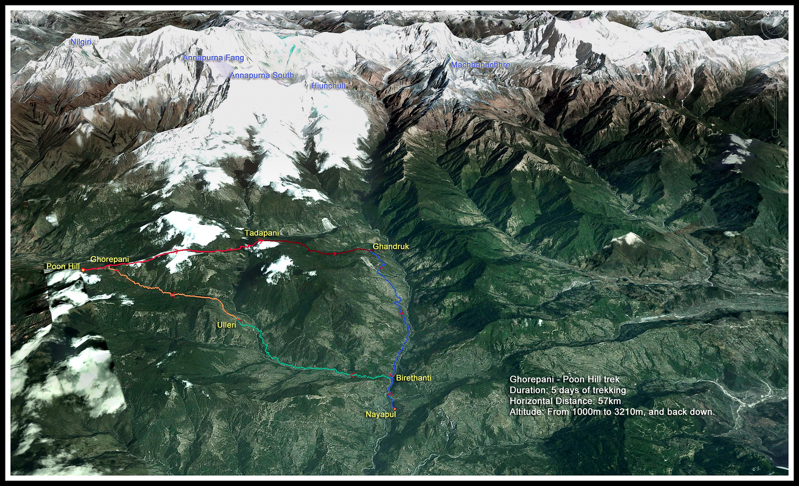
Click on the above picture for a larger version...
Back to the story...
Meanwhile, we were on the minibus.. and on our way to the starting point...
Well, as we quietly watched the scenery changed outside the moving bus, we start to catch glimpses of what is to come over the next few days.
The winding road keeps teasing us with sights of the Annapurna South.. one moment rising from behind houses...

Another moment peeping out from in between some branches...

Last edited:
limwhow
Senior Member
First Day of Trekking
Objective: to trek from Nayapul through the small villages all the way up to Ulleri.
The last steep ascend from Tikhedhunga to Ulleri is a sharp 500m cllimb.. 3200 steps it has ever been counted..
Hopefully the children (and ourselves) will be able to overcome this to push all the way up to Ulleri on this first day of the trek.
Why? Because if not, then we will have to spend the night down in Tikhedhunga, a notion which I do not really relish.
Because that will mean that on the second day we have another siong stretch to add on to.
"We will try to go all the way up to Ulleri," said Mahesh.
"Mahesh," I spoke from the bottom of my heart. "Let's just plan to go all the way up. I am quite sure the children can make it."
My mouth said. But I am not really that sure.
"Children, we are going to give this Ulleri a shot, OK?" I reassured the family.
"We can make it one. It's really better to spend the night up at Ulleri than to be at the foot of the mountain."
Off we got.
Last minute adjustment of the height of our trekking stick and checking of daypack straps and water bottles...

.. and the girls just cannot fathom the idea of pee-ing behind the rocks..
So die die must have one last pee before starting to walk...

FINALLY.

LOL.. Q 姐姐 a little Sua Koo, isn't she?
This is merely a gentle downslope leh.. Haven't even started the real trek...

[Translation: Q Jiejie: "Aiyoh.. this kind of road, how are we to walk?"]
Objective: to trek from Nayapul through the small villages all the way up to Ulleri.
The last steep ascend from Tikhedhunga to Ulleri is a sharp 500m cllimb.. 3200 steps it has ever been counted..
Hopefully the children (and ourselves) will be able to overcome this to push all the way up to Ulleri on this first day of the trek.
Why? Because if not, then we will have to spend the night down in Tikhedhunga, a notion which I do not really relish.
Because that will mean that on the second day we have another siong stretch to add on to.
"We will try to go all the way up to Ulleri," said Mahesh.
"Mahesh," I spoke from the bottom of my heart. "Let's just plan to go all the way up. I am quite sure the children can make it."
My mouth said. But I am not really that sure.
"Children, we are going to give this Ulleri a shot, OK?" I reassured the family.
"We can make it one. It's really better to spend the night up at Ulleri than to be at the foot of the mountain."
This is the actual GPS track of our trek from Nayapul up to Ulleri.

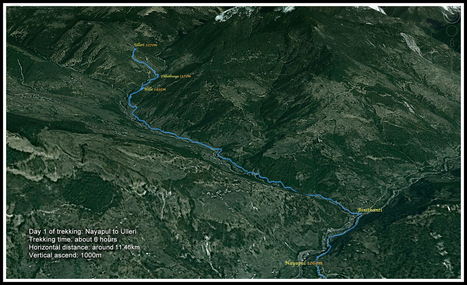
Click on the picture for a larger version.
The minibus stopped.
Off we got.
Last minute adjustment of the height of our trekking stick and checking of daypack straps and water bottles...
.. and the girls just cannot fathom the idea of pee-ing behind the rocks..
So die die must have one last pee before starting to walk...
FINALLY.
LOL.. Q 姐姐 a little Sua Koo, isn't she?
This is merely a gentle downslope leh.. Haven't even started the real trek...
[Translation: Q Jiejie: "Aiyoh.. this kind of road, how are we to walk?"]
Last edited:
This is a shot by SereneXMM of yours truly in my true-blue Nepali topi (hat) embarking on the trek.
I think I must have looked quite silly in my topi. Where on earth are there people trekking in topi?
No wonder I get funny gazes from the locals and porters as I trekked..

How many porters did you employ for this trip?
limwhow
Senior Member
Thank you so much for your kind words, DanMan!Excellent thread. Reading your narratives and seeing the pictures make me feel that I'm going on the trek too
This is a popular trek.. not too difficult.
In fact, most teenagers of adequate physical fitness can do it without problem.
How many porters did you employ for this trip?
Daoyin, haha... I asked for three.
They gave me four.
I think they see us too up.. scared that our luggages too heavy with all the hair dryers in them...
limwhow
Senior Member
From Nayapul to Birenthanti
It's a short walk to the Check point at Birenthanti... about half and hour.
It felt like a walk through Orchard Road. Really not much of a climb.
The Nayapul we saw was a small village with small shops selling some trekking stuffs..
Village elders sitting around warming themselves and children having fun..
Like a kampong...

I don't have the figures for the temperature at that time on that day.
But.. I remember it wasn't really that cold at 1000m. A baselayer, and a middle fleece layer.. and we were all 'walking' comfortably.

The children here must have seen plenty of trekkers along their ways.
They were quite oblivious to our presence. In fact, they were all having such fun playing their own games... I don't even know what they were playing.
Lots of laughter and action...

A lot of mischievious looks.. Haha..

It's a short walk to the Check point at Birenthanti... about half and hour.
It felt like a walk through Orchard Road. Really not much of a climb.
The Nayapul we saw was a small village with small shops selling some trekking stuffs..
Village elders sitting around warming themselves and children having fun..
Like a kampong...
I don't have the figures for the temperature at that time on that day.
But.. I remember it wasn't really that cold at 1000m. A baselayer, and a middle fleece layer.. and we were all 'walking' comfortably.
The children here must have seen plenty of trekkers along their ways.
They were quite oblivious to our presence. In fact, they were all having such fun playing their own games... I don't even know what they were playing.
Lots of laughter and action...
A lot of mischievious looks.. Haha..
Last edited:
limwhow
Senior Member
Crossing the Modi Khola River...
The Modi Khola River flows down the Ghorepani Birenthanti area and feeds this lovely land.
It originates from Annapurna Base Camp and along its way, picks up several tributaries.
Thus, we found ourselves crossing the Modi Khola time and time again on suspensions bridges as we trekked.
Sometimes we would be walking the mountain tracks, with the Modi Khola roaring just below us.
Other times we would make a turn, to come into full view of its splendour right ahead of us.
Here is the first suspension bridge we crossed right after Nayapul..
Mahesh is just right ahead of me...
[video=youtube_share;Aw0cimgQN_E]http://youtu.be/Aw0cimgQN_E[/video]
limwhow
Senior Member
Birenthanti...!
Our lungs are still expansive,
our legs are still fresh,
our brains are still alert.
[video=youtube_share;FI4ZeSBP5R4]http://youtu.be/FI4ZeSBP5R4[/video]
And we crossed the huge metal bridge and saw the check point at Birethanti...

Mahesh said: "Ok, this is the check point at Birethanti. Now we are going to trek up from the track on the left side. When we come back we would have made one round and will be trekking down along the track on the right side of this village."
Well, good.
At least now I know where we are going up, and where we will be coming down to.
But honestly, I still didn't know how the track conditions will be for we have only been walking for half and hour, and so far the path has been nice and smooth.
We heard sounds of crying as we made the turn, and we came upon this young little toddler boy being washed up by his father.
The children jokingly made a remark that they would cry too if they were to bathe like this for it was really cold.

Finally! Some steps.. warmly welcomed by the newbies...

Huh! Wait until later when more tougher and steeper steps present themselves!
Our lungs are still expansive,
our legs are still fresh,
our brains are still alert.
[video=youtube_share;FI4ZeSBP5R4]http://youtu.be/FI4ZeSBP5R4[/video]
And we crossed the huge metal bridge and saw the check point at Birethanti...
Mahesh said: "Ok, this is the check point at Birethanti. Now we are going to trek up from the track on the left side. When we come back we would have made one round and will be trekking down along the track on the right side of this village."
Well, good.
At least now I know where we are going up, and where we will be coming down to.
But honestly, I still didn't know how the track conditions will be for we have only been walking for half and hour, and so far the path has been nice and smooth.
We heard sounds of crying as we made the turn, and we came upon this young little toddler boy being washed up by his father.
The children jokingly made a remark that they would cry too if they were to bathe like this for it was really cold.
Finally! Some steps.. warmly welcomed by the newbies...
Huh! Wait until later when more tougher and steeper steps present themselves!
limwhow
Senior Member
Very soon, we started to feel a little bit of strain on our cardiovascular system as the gradient of the track took a turn northwards.
Still, it was a wide track which we were walking upon.
Mahesh explained that this is the motor track, which can be driven on by vehicles, thus the width.
But this motor track would end shortly and abruptly converge into a narrower trekking path with rocky steps and stony pavements.
That's when the fun will really begin.
Meanwhile, we enjoyed the wide track with all its nonsensical ups and downs..
The porters were just beginning to warm up. We could still see them.
Soon, they would forge ahead and disappear into nowhere with our hair dryers and makan, leaving us far far behind.

[Shot taken by Fann the Penguin.]
Up the track we went...

And Ya Ya Kapong the Queen SereneXMM went...
Here she was still happily plodding her trekking sticks here and there, left and right...
Her daypack was still feeling light on her back..
I quietly wondered how long more it would take before she started to kao beh kao boo...

Still, a man has got to do what a man has got to do.
The son has surged ahead with the porters somewhere along the track.
The walkie talkies, which every one has one strapped securely to their day packs, came in useful...

[Shot taken by SereneXMM]
I didn't have a chance to see this shot until I reviewed SereneXMM's pictures.. And wow...
Man, Don't I just look 'sat-sat' with that Nepali topi and my trekking stick?!
LOL...
[Translation: Sat-Sat = steady poon pee pee = very smart-looking]
Still, it was a wide track which we were walking upon.
Mahesh explained that this is the motor track, which can be driven on by vehicles, thus the width.
But this motor track would end shortly and abruptly converge into a narrower trekking path with rocky steps and stony pavements.
That's when the fun will really begin.
Meanwhile, we enjoyed the wide track with all its nonsensical ups and downs..
The porters were just beginning to warm up. We could still see them.
Soon, they would forge ahead and disappear into nowhere with our hair dryers and makan, leaving us far far behind.
[Shot taken by Fann the Penguin.]
Up the track we went...
And Ya Ya Kapong the Queen SereneXMM went...
Here she was still happily plodding her trekking sticks here and there, left and right...
Her daypack was still feeling light on her back..
I quietly wondered how long more it would take before she started to kao beh kao boo...
Still, a man has got to do what a man has got to do.
The son has surged ahead with the porters somewhere along the track.
The walkie talkies, which every one has one strapped securely to their day packs, came in useful...
[Shot taken by SereneXMM]
I didn't have a chance to see this shot until I reviewed SereneXMM's pictures.. And wow...
Man, Don't I just look 'sat-sat' with that Nepali topi and my trekking stick?!
LOL...
[Translation: Sat-Sat = steady poon pee pee = very smart-looking]
Last edited:
limwhow
Senior Member
... As the hours went on, and the gradient got steeper, and the sun started beating down...
As expected, some time into the trek, we started feeling the heat, as our bodies became warmer with the exertion, and the sun started smiling BIG BIG at us.
Most of us started taking off our middle fleece layer or the outer shell, and just trekked with the base layer and/or T shirt.
The Modi Khola kept coming into view and disappearing out of sight as the curvy wurvy track turned left and right.
For those of us here who wonder how the Modi Khola looks like, here is a shot by Fann the Penguin...
[.. and I am not referring to the trekking shoes...]

OK, OK, Penguin. Stop that nonsense about taking pictures after picture of your feet and let's get going..
The track really started to tekan [translation: press, or in a more literal meaning, punish] us with an ever increasing gradient.
I began to feel a little breathless, but heck.. what is a little bit of exercise, right?
We didn't come to Nepal to do shopping mah, right?

The gap between ourselves widened.
The son is certainly nowhere to be seen by now, leaving the girls and myself behind...
Every one started to drift into their own thoughts...
Some complaining...

Some kao-beh kao-boo-ing...

... and some, forever thinking about their hair dryers...

As expected, some time into the trek, we started feeling the heat, as our bodies became warmer with the exertion, and the sun started smiling BIG BIG at us.
Most of us started taking off our middle fleece layer or the outer shell, and just trekked with the base layer and/or T shirt.
The Modi Khola kept coming into view and disappearing out of sight as the curvy wurvy track turned left and right.
For those of us here who wonder how the Modi Khola looks like, here is a shot by Fann the Penguin...
[.. and I am not referring to the trekking shoes...]
OK, OK, Penguin. Stop that nonsense about taking pictures after picture of your feet and let's get going..
The track really started to tekan [translation: press, or in a more literal meaning, punish] us with an ever increasing gradient.
I began to feel a little breathless, but heck.. what is a little bit of exercise, right?
We didn't come to Nepal to do shopping mah, right?
The gap between ourselves widened.
The son is certainly nowhere to be seen by now, leaving the girls and myself behind...
Every one started to drift into their own thoughts...
Some complaining...
Some kao-beh kao-boo-ing...
... and some, forever thinking about their hair dryers...
limwhow
Senior Member
... Huh? What you saying? Obstacles along the track...?
Seasoned trekker will tell you that anything can happen along the treks.
Like on a motorway, you will have either road hogs, or speeding bullets posing as challenges..
So it came as no surprise when at one moment Q was admiring herself with the mountains...

.. the next moment we hear Mahesh shouting in front...

Nonchalantly the four legged obstacles walked by us, throwing Q a look as though asking her:
Kua Si Mi...!!??
[Translation: What you look at..!!??]

Well, here we are at around 1000+m altitude. The commonly encountered domestiated livestocks are buffaloes, horses, ponies, goats, ducks, chicken and such.
There aren't any yaks at this level.
The yaks can only survive at higher altitude of 3000m and above.
So the question that I kept asking myself was: "Will we see yaks at the higher altitudes?"
Well, let's see how the answer comes.
Seasoned trekker will tell you that anything can happen along the treks.
Like on a motorway, you will have either road hogs, or speeding bullets posing as challenges..
So it came as no surprise when at one moment Q was admiring herself with the mountains...
.. the next moment we hear Mahesh shouting in front...
Nonchalantly the four legged obstacles walked by us, throwing Q a look as though asking her:
Kua Si Mi...!!??
[Translation: What you look at..!!??]
Well, here we are at around 1000+m altitude. The commonly encountered domestiated livestocks are buffaloes, horses, ponies, goats, ducks, chicken and such.
There aren't any yaks at this level.
The yaks can only survive at higher altitude of 3000m and above.
So the question that I kept asking myself was: "Will we see yaks at the higher altitudes?"
Well, let's see how the answer comes.
limwhow
Senior Member
... Some more obstacle..?!?!
Man, this track is beginning to feel like some kind of an SOC (Standard Obstacle Course) liao...
Suddenly my walkie talkie crackled:
"Pa, a big water puddle ahead..." It was the son.
He is beginning to be like some kind of scout for the whole team.
He would walkie-talkie to the whole group about anything he comes into contact right in front, giving us prior warning.
That was really good. I am beginning to like the walkie talkies..
And here, a big water puddle...

How to cross?
Only a thin slither of rocks on the side allows for stepping space...
Well, after this video, every yak in the mountain can hear SereneXMM screaming her lungs out as she struggled to find her footing on the rocks..
Silly girl...
[video=youtube_share;ME4vzsMwk-s]http://youtu.be/ME4vzsMwk-s[/video]
I can't help myself laughing my a** off when she screamed like that... LOL.
Man, this track is beginning to feel like some kind of an SOC (Standard Obstacle Course) liao...
Suddenly my walkie talkie crackled:
"Pa, a big water puddle ahead..." It was the son.
He is beginning to be like some kind of scout for the whole team.
He would walkie-talkie to the whole group about anything he comes into contact right in front, giving us prior warning.
That was really good. I am beginning to like the walkie talkies..
And here, a big water puddle...
How to cross?
Only a thin slither of rocks on the side allows for stepping space...
Well, after this video, every yak in the mountain can hear SereneXMM screaming her lungs out as she struggled to find her footing on the rocks..
Silly girl...
[video=youtube_share;ME4vzsMwk-s]http://youtu.be/ME4vzsMwk-s[/video]
I can't help myself laughing my a** off when she screamed like that... LOL.
limwhow
Senior Member
Young kids can go trekking one meh...?
[Singlish. Translation: Can young kids go trekking?]
Yah, that was what some of my friends asked.
Well, until this moment in the trek, I didn't have the answer yet.
But now, in restrospect, my answer is a strong affirmative.
Of course they can. And mind you, they may even do a better job than you and I put together.
Look at them. They are just children only.
What is the mountain? What is a steep slope with rocky step haphazardly arranged?
What is freezing cold without heater and only your clothes and your sleeping bag to keep you warm?
What is frozen icy tracks so slippery that one misstep and down you go the cliff centimetres away from you?
They know nothing of that.
And they probably fear none.
Similar threads
- Replies
- 0
- Views
- 3K
- Replies
- 0
- Views
- 3K
- Replies
- 0
- Views
- 2K
- Replies
- 0
- Views
- 1K
- Replies
- 0
- Views
- 1K