You are using an out of date browser. It may not display this or other websites correctly.
You should upgrade or use an alternative browser.
You should upgrade or use an alternative browser.
"Do you know the world?" --Competition--
- Thread starter Poseidon88
- Start date
LAZyNPL
New Member
Not at Mustagh Ata, note it's a historical town; not just in the wilderness.
The lady is also not an Uzbek.
Even though it is not in Mustagh Ata, but traveller who made all the way to M/A will most likely visit the mysterious town as well.
ZerocoolAstra
Senior Member
seems like the town of Tashkurgan was a pretty prominent location along the Silk Road in its history, so that's my guess... ")
Wikipedia on Tashkurgan
add on:
THIS person's photos show pretty similar terrain, though it could be similar throughout this region
Wikipedia on Tashkurgan
add on:
THIS person's photos show pretty similar terrain, though it could be similar throughout this region
Last edited:
LAZyNPL
New Member
seems like the town of Tashkurgan was a pretty prominent location along the Silk Road in its history, so that's my guess...
Wikipedia on Tashkurgan
add on:
THIS person's photos show pretty similar terrain, though it could be similar throughout this region
Haha, finally you found a right source of info!
Yes, the farmland is taken from top the ruins of fortress in Taxkorgan aka Tushkurgen; the principal town and seat of Tashkurgan Tajik Autonomous County, Xinjiang, China.
However, the link of photos u found is mainly taken around the foot of Mt Mustagh and the Karakul Lake; along the Karakorum Highway; before reaching Taxkorgan.
Taxkorgan is a small, harmony and also the west-most town of China. Different ethnic groups can be seen everywhere in town due to the multi-neighbour border.
My Karakoram trail (and the other part of Xinjiang) proved to be one of the most unforgettable travel experience I ever had. As it is not appropriate to flood this thread with my own photos, I will take my sharing in another thread.
Now, ZerocoolAstra; your turn!!!
ZerocoolAstra
Senior Member
Haha, finally you found a right source of info!
Yes, the farmland is taken from top the ruins of fortress in Taxkorgan aka Tushkurgen; the principal town and seat of Tashkurgan Tajik Autonomous County, Xinjiang, China.
However, the link of photos u found is mainly taken around the foot of Mt Mustagh and the Karakul Lake; along the Karakorum Highway; before reaching Taxkorgan.
Taxkorgan is a small, harmony and also the west-most town of China. Different ethnic groups can be seen everywhere in town due to the multi-neighbour border.
My Karakoram trail (and the other part of Xinjiang) proved to be one of the most unforgettable travel experience I ever had. As it is not appropriate to flood this thread with my own photos, I will take my sharing in another thread.
Now, ZerocoolAstra; your turn!!!
:vhappy:
wah! Such a lucky guess!
 Your clues really helped, and I learned something.
Anyway since I am unable to link to any of my photo galleries due to current internet restrictions, it would be best to forfeit my turn and let you nominate someone else or post another photo, so as to keep this competition going without undue delay
")
Then I let the honor to Daredevil123 to post new photo, as he is the 2nd closest guess.
Next up....
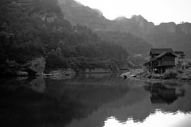
This should be an easy one if you watch lots of TV series.
Hmm... familiar mountain n architecture.
Looks like somewhere in å¼*家界?!
I am sorry but I cannot see your non-english characters. Some problem with encoding?
coolthought
Senior Member
taihu?
taihu?
Think the decoding got problem.
My answer is Zhang-Jia-Jiie.
Nope... A hint... a big one..
Two martial arts TV series were filmed there... one has something to do with birds, and one has something to do with laughing.
coolthought
Senior Member
jiujiang?
coolthought
Senior Member
Thanks for your big hint.
I believe the correct answer is ZheJiang XinChang town.
think you are right 浙江新昌... but I let DD123 to confirm.
Thanks for your big hint.
I believe the correct answer is ZheJiang XinChang town.
Yup! The place is called "穿岩十九峰景区", Xinchang town, under Shaoxing city, Zhejiang Province.
It was filming location for 笑傲江湖 and 射雕英雄传.
Back to you LAZyNPL.
Last edited:

Similar threads
- Replies
- 0
- Views
- 190
- Replies
- 0
- Views
- 217
- Replies
- 0
- Views
- 211
- Replies
- 0
- Views
- 207
- Replies
- 0
- Views
- 159